|
|
|
|
|
Maps have for centuries played a key role in warfare, and the French and Indian War was no exception. Commanders on both sides relied on maps as they made their decisions about troop and fleet movements, where to engage the enemy, and what territory to try to hold. These maps served as tools for strategists who determined the destiny of empires. |
 |
When they drew their maps, 18th-century mapmakers, or cartographers, relied upon a variety of sources. Despite their best efforts, inaccuracies abounded. Most often they consulted the work of other mapmakers; rarely did they conduct their own surveys. As a result mistakes carried over from one map to the next. |
|
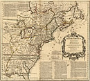
Politics also played a part in cartographers’ work, especially since most depended on a monarch or other influential aristocrat for employment. Consequently, they usually found it worthwhile to show as much territory as possible under a patron's command and as little as possible under that of a national rival. Look closely, for example, at the details and explanations on the map “North America from the French of Mr. D’Anville.” Copied from a French original, this English map includes an aggressive argument against French claims to the territory depicted. |
|
In other instances, a cartographer who was uncertain of geographic features might draw them in as he or she saw fit. On plate 2 of “A Map of the British and French Dominions in North America,” for example, cartographer John Mitchell left a good deal blank and simply speculated about the origin of the Mississippi River. Nonetheless, these maps still offered the most reliable information available about distant lands. |
|
The maps in this exhibition constitute only a small sample of the hundreds drawn to depict North America during the French and Indian War. Many of these maps are here at the Massachusetts Historical Society. For historians looking at them today, they provide valuable information about the planning and conduct of the war. By examining the illustrations and marginal notes closely, one can tell a great deal about a place, matters of geography, or how the combatants viewed their world. Look, for example, at the map and illustrations depicting the battle of Lake George in 1755. From this what can you tell about the nature of war in North America? |
|
