Return to MHS homepage


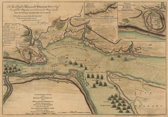
Drawn by an officer of the Royal Navy, this map depicts the British and French tactical positions at the time of the climatic battle on the Plains of Abraham, September 13, 1759. That engagement led to a French defeat and the deaths of both commanders, Montcalm and Wolfe; the city surrendered five days later. Wolfe’s overwhelming advantages are evident. The British fleet dominates the river, and British land forces control Isle of Orleans as well as the shore directly opposite Quebec. At “The Landing Place” (to the left on the Quebec side), Wolfe’s soldiers climbed the heights to a position behind the French during the night of September 12–13, thus forcing Montcalm to leave the city and do battle on the Plains of Abraham. link to an engraving of the city of Quebec

      Click on a section of the map to enlarge.

“An Authentic Plan of the River St. Laurence from Sillery, to the Fall of Montmorenci, with the Operations of the Siege of Quebec under the Command of Vice-Adml. Saunders & Major Genl. Wolfe down to the 5 Sepr. 1759.”

Titles of two inset maps:
"Part of the Upper River of St. Laurence" and "A View of the Action Gained by the English Sepr. 13, 1759 near Quebec."

Drawing by “a Captain in his Majesties Navy,” unknown engraver, possibly Robert Sayer.
London: Published by Thomas Jefferys, 1759.
Dimensions of entire sheet: 21 3/4 X 14 5/8 inches.
Dimensions of image: 18 5/8 X 12 7/8 inches.
Plate number 16 from Atlas Des Colonies Angloises en Amerique (after 1777). [Title of atlas taken from manuscript title page.]

Click here to view citations for all of the maps.