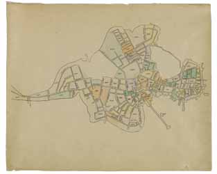
Clough's Atlas of Boston neighborhoods based on the Direct Tax Census of 1798
To order an image, navigate to the full
display and click "request this image"
on the blue toolbar.
-
Choose an alternate description of this item written for these projects:
- MHS 225th Anniversary
This atlas by Samuel Clough (1873-1949) consists of manuscript maps of fifty-five blocks of Boston showing street layouts and property ownership in 1798. Clough obtained this information from the Direct Tax Census of 1798. The front leaf of the atlas is a drawing of the Shawmut peninsula with color-coded blocks that correspond to the maps within the atlas.
It is unclear whether this atlas was created before, after, or concurrently with a series of oversize 1798 plates, but Clough used similar features such as the block property number system.
Clough's work on the atlas is part of an unfinished topographical history of Boston. Clough was a draftsman for Boston Edison Company and worked for the Boston Navy Yard in Charlestown. This map forms a part of the Samuel Chester Clough research Materials toward a topographical history of Boston, a manuscript collection at the Massachusetts Historical Society. Please see the online finding aid for the Clough research materials. Included in the Clough collection are many notebooks and research materials that explain the atlas, as well as an unfinished manuscript on the history of Boston.

