Collections Online
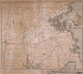
To the Hone. Jno. Hancock Esqre. President of the Continental Congress; This Map of the Seat of Civil War in America is Respectfully Inscribed
To order an image, navigate to the full
display and click "request this image"
on the blue toolbar.
-
Choose an alternate description of this item written for these projects:
- MHS 225th Anniversary
- Main description
[ This description is from the project: Witness to America's Past ]
Philadelphia, July 12, 1775. 'It is PROPOSED to PRINT, And in a few days will be published, A COMPLETE and ELEGANT MAP, from BOSTON to WORCESTER, PROVIDENCE and SALEM. Shewing the SEAT of the present unhappy CIVIL WAR in North-America. Author, BERNARD ROMANS ....' (Footnote 1)
The American Revolution saw a vast increase and improvement in the mapping of the colonies, largely for practical military purposes, but also for the graphic display of news of the war, both in England and in America. The presence of a large number of regular army officers with professional training or experience in mapmaking gave the British an advantage in this field. A small number of Americans (Richard Gridley and Osgood Carleton, to name a couple), had formal cartographic training, but early in the war George Washington was forced to draw his own maps and plans to illustrate and coordinate army movements. For the most part, the American cause was dependent on European and ex-British army officers for technical expertise. Bernard Romans, the cartographer of this, the first map printed in America to show Massachusetts as an independent state, was one of the small number of ex-British officers and officials with technical training who gave their allegiance to their new country. (Footnote 2)
Born in Holland about 1720, Bernard Romans had some formal or practical training as an artillerist and military engineer, but details of his early life and career are obscure. In 1766, while engaged in trade, Romans was shipwrecked off Florida. There, he secured employment as a surveyor for Georgia, and later in the British colonial service for the Southern Department. His most famous work was a natural history of Florida that accompanied an enormous twelve- by seven-foot map of that colony, "an ornamental piece of furniture," as it was de-scribed in the Boston Gazette in 1774 when Romans came to Boston to secure subscriptions and to arrange for Paul Revere to engrave the map. Romans was a frequent contributor to Isaiah Thomas's Royal American Magazine, published in Boston in 1774, and the same year was elected a member of the American Philosophical Society, the first learned society in America. (Footnote 3)
When the Revolutionary War began, Romans threw his lot with the American cause; he was in Connecticut when fighting began and joined the expedition from that colony that took part in the capture of Ticonderoga. He supervised the first efforts to remove the cannon from the fortress. In the summer of 1775, Romans was employed by the Committee of Safety in New York to design fortifications for the Hudson River. In this, as with much of his military career, Romans was unhappy and unsuccessful. In spite of the war emergency, Romans found time in the summer of 1775 to undertake the Map of the Seat of Civil War showing Boston during the American siege. The inset view in the lower right corner of the map shows the British lines on Boston Neck at approximately the same time Lieutenant Williams was making his sketches from within the British lines, looking in the opposite direction. (Footnote 4)
Despite contemporary newspaper advertisements that claimed Romans was "the most able draughtsman in America," and had been present at all of the "late engagements," there is no evidence that he was at Concord and Lexington, or the Battle of Bunker Hill. His map of eastern Massachusetts is wildly inaccurate in many local geographical details, but it well served its purpose of graphically conveying information concerning the scene of the fighting to the rest of the colonies. (Footnote 5)
Romans served in the Philadelphia artillery during the abortive invasion of Canada in 1776, and in the construction of American defenses later in the war. He found time during his military service to produce commercial maps of Connecticut and the northern theater of military operations, as well as a history of his homeland. According to his widow's pension request, written more than sixty years later, Romans was captured by the British in 1780 during another unlucky voyage, and died under mysterious circumstances at the end of the war. (Footnote 6)
Although Romans's studies in natural history were not well thought of by the founders of the Society, his other work was collected for the library. Romans's history of his homeland, Annals of the Troubles in the Netherlands (Hartford, 1778), was one of the first gifts to the library of the Society in 1792, and this map joined it in the Society's collections within the first decade after its founding. (Footnote 7)
1. Rivington's New-York Gazetteer, Aug. 10, 1775.
2. Ristow, Walter W. American Maps and Mapmakers: Commercial Cartography in the Nineteenth Century. Detroit: Wayne State University Press,1985, pp. 35-47.
3. Phillips, P. Lee. Notes on the Life and Works of Bernard Romans. Publications of the Florida HIstorical Society, no. 2. Deland, Fla.: The Florida State Historical Society, 1924, pp. 24-26, 45-50.
4. Ibid., pp. 81-82.
5. Advertisements from the Pennsylvania Gazette and Rivington's New-York Gazetteer, reprinted in Ibid., pp. 81-83.
6. Phillips, P. Lee. Notes on the Life and Works of Bernard Romans. Publications of the Florida HIstorical Society, no. 2. Deland, Fla.: The Florida State Historical Society, 1924, pp. 68-69.
7. Collections of the Massachusetts Historical Society. 5th ser., 83 vols. Boston: The Society. 3:57.

