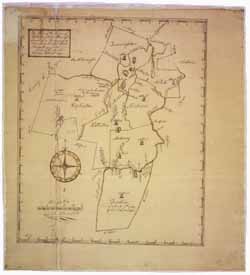
Manuscript plan of the town of Holliston, 12 February 1793
To order an image, navigate to the full
display and click "request this image"
on the blue toolbar.
Samuel Bullard's manuscript plan of the town of Holliston in 1793 shows the location of ponds, rivers, meeting houses, farms, trees, and bridges. Bullard surveyed the neighboring towns of Framingham, Hopkinton, Medway, Franklin, Sherburne (Sherborn), and Natick. He includes the courses of the Sudbury River and the Charles River. A note indicates that Bullard surveyed Franklin on 9 March 1784. The location of Jasper Rock is marked as the former southwestern corner of Natick. The surrounding towns of the surveyed area are also identified including Wrentham, Bellingham, Milford, Southborough, Marlborough, Sudbury, East Sudbury, Weston, Needham, Dover, and Medfield.

