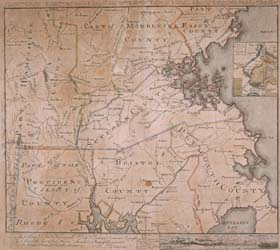
To the Hone. Jno. Hancock Esqre. President of the Continental Congress; This Map of the Seat of Civil War in America is Respectfully Inscribed
To order an image, navigate to the full
display and click "request this image"
on the blue toolbar.
-
Choose an alternate description of this item written for these projects:
- Witness to America's Past
- MHS 225th Anniversary
This map, drawn by Bernard Romans in 1775, is the first map printed in America to show Massachusetts as an independent state. The map shows rivers, creeks, hills, and towns within each existing county in Massachusetts, as well as portions of Connecticut and Rhode Island. A detail of the Boston area includes the Shawmut peninsula, Charlestown, Cambridge, and Roxbury. Across the top of the map, Romans listed the islands in Boston Harbor. Although the map is inaccurate in some local geographical details, it served its purpose of graphically conveying information concerning the scene of the fighting of various battles during the American Revolution to the rest of the colonies. The inaccuracies in the map are embodied primarily through the compression of scale of Romans' cartographic representations of Massachusetts and Rhode Island.
Romans, a navigator, surveyor, cartographer, and soldier, was one of a small number of expatriate British officers and officials with technical training who gave their allegiance to their new country. He is most famous for maps of the southeastern United States, particularly Florida, in the period leading up to 1775.

