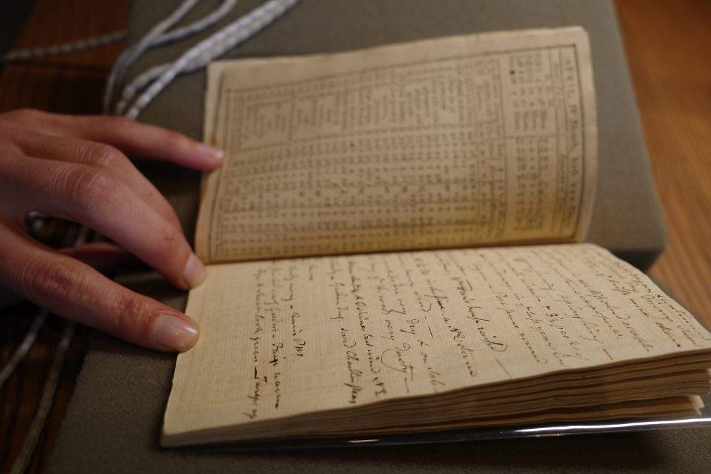
For the last few months, I’ve been telling you about Henrietta Schroeder, a 14-year-old American girl on a European tour with her family in 1889. Her diary in the Stout family papers is a very entertaining record of that trip.
Today I’d like to introduce you to some of her friends. One of Henrietta’s most endearing qualities, I think, is her love for her friends, so I wanted to know more about the girls that meant so much to her.
The Curiosity Raising Club
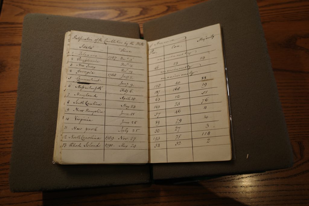
On October 19, 1889, Henrietta had a great idea: “Lina Wetherill, Edith Speyers & Lena Schroeder & myself are going to get up a club, called the ‘Cur[i]osity Raising Club,’ […] for the purpose of getting up the cur[i]osity of others.” Just who were these curious young women?
I’ve mentioned Lina Wetherill before – that is, Caroline Bowen Wetherill, Henrietta’s best friend. Henrietta often wrote about Lina in her diary like this: “Oh! how I long for her, pray for her, love her. Oh! how I wish I could see her over here and (if only for an hour) press her to my heart once more, and be able to hear her voice, and feel her warm kiss once more.”
Lina, the daughter of Civil War veteran Francis Dring Wetherill, was born in 1876 and grew up in Philadelphia. At the age of 30, on a trans-Atlantic ocean liner, Lina met a 42-year-old bachelor lawyer from Seattle named Josiah Collins. They married a few months later and went on to have two sons together. Lina died in Seattle at the age of 80. I sincerely hope she and Henrietta stayed friends for the rest of their lives.
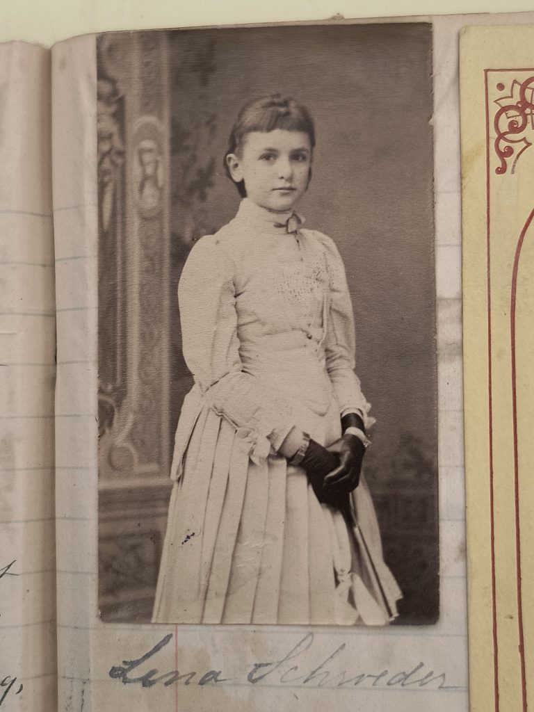
Confusingly, there was another Lena in Henrietta’s life, this one with an “e.” Here she is in an adorable photograph pasted into Henrietta’s diary.
Photograph of Lena Schroeder, ca. 1889
This Lena was Selina Richards Schroeder, Henrietta’s first cousin once removed, the daughter of New York cotton broker Gilliat Schroeder. She was born in 1875, just ten days before Henrietta. The Historical Society of Pennsylvania holds three diaries kept by Lena between 1888 and 1891. They look very similar to Henrietta’s; one of them even includes her picture!
In 1896, Gilliat Schroeder made some bad investments, and as the New York newspapers quaintly expressed it, “unfortunate speculation swept away the [family’s] fortune.” Lena, who was just 20 years old, went into business as a dressmaker to support her family, soon moving to larger premises in Manhattan and employing at least 25 other women. Her entrepreneurship was lauded in contemporary papers and in an 1898 book called What Women Can Earn.
The last member of the Curiosity Raising Club was Edith Lawrence Speyers, also of New York, Lena Schroeder’s first cousin through their mothers, Louisa and Selina Lawrence. Edith was also born in 1875, the oldest of the friends by a few months.
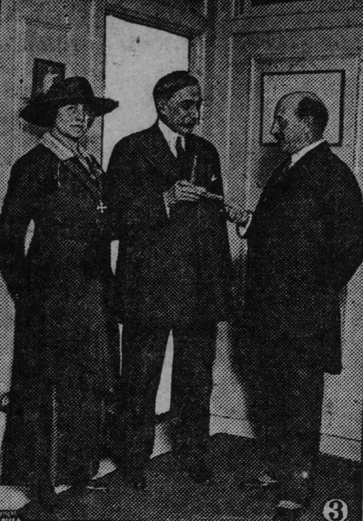
Edith would become best known as a leader in relief organizations during both world wars. She was chair of the National League for Women’s Service during World War I and, in 1920, founded the Dug Out, a Manhattan club for disabled veterans. For her various wartime efforts, she was decorated by the governments of France, Romania, and Serbia. But Edith didn’t rest on her laurels. She headed the National Women’s Council of the Navy League during World War II, when she was in her sixties. She was widowed twice and died in 1949.
Edith McVickar (née Speyers) and Breck Trowbridge receiving honors from Romanian politician Gogu Negulescu, clipped from the Dodge Center Record, October 9, 1919
I hope you’ll join me as I pick up Henrietta’s story in a future post!
By Bianca Laliberté, Andrew Oliver Fellow, 2025-2026
I have not yet encountered a philosopher dealing with the reality of archival research who has not confessed to me the ache and discomfort they experienced once actually immersed in the work. Fair enough: the Foucauldian confrontation of the philosophical tradition with the messy realm of the archives would not come about without irritation. Archival research breaks the flow of the tightly configured reading processes that inform this tradition. It cracks open the philosophical experience, leaving much room for emotional and cognitive dissonance, opening the door to a sort of chaotic sentiment.
Figure 1. Jeremy Belknap Diary, 1786. Massachusetts Historical Society, Ms. N-1827; P-380, Boxes A.1.10-11 III.
I wish to bring attention to the fact that such a Western philosophical narrative holds space for a rather European point of view. Unless we think of the development of American thought as a mere extension of European thought—which I can’t resign myself to doing for critical reasons analogous to the ones put forward by Ned Blackhawk, we must admit that, on the other side of the Atlantic, the logic of archival research somewhat follows an inverted logic. When facing the intellectual history of early America, one could argue that the chaotic sentiment is not experienced as the product of a philosophical breakthrough. It appears to me to be much more accurately perceived as the effect of an intrinsic quality. For researchers looking into materials from the seventeenth and eighteen centuries, the cognitive need to confront and defeat the dispersion of what we could call “American thought” through the grey world of archives and documents tends to feel rather unavoidable. Chronologically speaking, first comes the dissemination of the body of modern American thought, then come its otherwise structured forms.
Figure 2. Jeremy Belknap Diary, 1786. Massachusetts Historical Society, Ms. N-1827; P-380, Boxes A.1.10-11 III
Gérard Deledalle, the French philosopher who introduced American pragmatism in France during the golden years of continental philosophy, did not share these preoccupations. His framing of the beginnings of American philosophy (1954) led him no further back than to written oeuvres that could arguably be compared to textual forms that are familiar to the philosophical tradition. After rapidly covering contributions from individual thinkers like Samuel Johnson, Jonathan Edwards, or Thomas Jefferson, he rushes to address the emergence of American transcendentalism. Many early Americanists, on the other hand, have tended to be much more generous—sometimes too much so. Following patterns observable in early American discourses, many of them willingly identify the unarticulated philosophies of the seventeenth and eighteen-century American context as “practical” and even as “pragmatic” ones, sometimes without giving the notion of philosophy itself any further thought. This loosening of the notion of philosophy is not only the fruit of academic developments, however. The approaches to knowledge that drove eighteenth-century-born American learned societies certainly contributed to it.
Figure 3. Jeremy Belknap Diary, 1787. Massachusetts Historical Society, Ms. N-1827; P-380, Boxes A.1.10-11 III.
In Jeremy Belknap’s annotated almanacs, calendar pages and blank pages covered with manuscript notes drastically alternate (Figures 1–4). These artefacts convey a powerful image of his personal experience of the disruption of continuous time. And so does the gathering of the first collections of the MHS, through which he certainly dealt with the interrupting rhythm of archival dissemination, even more so given that the organizing principles that led his endeavor surpassed the bibliographical and archival categories. His approach could, in that sense, be called “intermedial”: the spectrum of material he embraced included objects, maps, images, and so-called “curiosities”. Belknap never bestowed his collecting philosophy with a formal theorization, and it would be quite dubious to frame him as a philosopher. However, to build on a statement articulated by Abram C. Van Engen (2023) in relation to the discipline of history, the impact that individuals like Belknap, Ebenezer Hazard, and John Pintard have had on the development of American intellectual history at large has yet been overlooked by scholars attached to the various disciplines that draw on the gigantic pool of early texts and artefacts that they collected. This postulate includes—or should include—philosophy and intellectual history.
Figure 4. Jeremy Belknap Diary, 1787. Massachusetts Historical Society, Ms. N-1827; P-380, Boxes A.1.10-11 III.
One way to think of this interdisciplinary phenomenon in general terms would be to verify to what extent it sheds light on the horizon of a troubling possibility, which Van Engen touches upon: the disseminative logic that determines the making of the various fields of Early America to this day stood at the heart of Belknap’s nationalist project. This is, at least, what I want to leave for the reader of this blog post to think about. Continental standpoints of philosophy fed the critique of American nationalism from the 1970s on. We need a philosophy of archival research which recognizes that the unreflective application of these standpoints to the American proto-imperial context runs the risk of blinding us to the task here at hand. From the perspective of the study of Early America, the study of institutional history and the critique of structures of power that motivated Michel Foucault’s engagement with archival research cannot target a monolithic form of philosophy alone. It must be capable of weighing the fact that the American nationalist metaphysic, which Belknap and his associates translated into a practice of gathering, embodies a sort of democratic and inclusive quality. One could speak, using the terms of Jacques Rancière—and not without a touch of irony—of a democracy of the sensible, where sheets of paper, records, images, and Indigenous art pieces, are put together for the State’s and citizen’s eye to see and exhibit. This invites us to acknowledge that our defense of democratic approaches to research thus requires deeper thinking and renewed forms of investigation, which might prove necessary to face the symptomatic return of nationalism.
And of course, following this path, one should expect to experience a certain level of ache and discomfort.
Further Reading:
For a critique of the denial of the cost of political and imperial “independence” of the United States, view Blackhawk, Ned. The Rediscovery of America. Native Peoples and the Unmaking of U.S. History. New Haven, Yale University, 2023—and p.1 in particular, where he writes: “Historians have largely followed suit in focusing on Europeans and their descendants: Puritans governing a commonwealth in a wilderness; pioneers settling western frontiers; and European immigrants huddled upon Atlantic shores. Scholars have long conflated U.S. history with Europeans, maintaining that the United States evolved from its British settlements”.
Deledalle, Gérard. Histoire de la philosophie américaine, Presses universitaires de France, Paris, 1954.
For a critique of unreflective applications of philosophical interpretation to the Early American context, view Beard, Charles. The Supreme Court and the Constitution. New York, Paisley Press, 1912. On p.79, Beard argued that the Founding Fathers and the Framers of the Constitution, “were not philosophers, but men of business and property . . . and had no problem with the system of class rule and the strong centralization of government which existed in England”.
Van Engen, Abram C. (2023). “Pursuing the “True History” of America” in The Massachusetts Historical Review, Published by the Massachusetts Historical Society, Vol 21, 2020. I wish to thank Ondine Le Blanc for referring this brilliant article to me.
Adams Family Correspondence, volume 17, forthcoming in 2027, is filled with politics, diplomacy, war, and strong opinions, but also many personal changes for the Adams family. Several beloved Adams family members and dear friends die between 1809 and 1812, the years covered in this volume. In the midst of this sorrow, John and Abigail watch their grandchildren develop into teenagers and young adults. Letters of the third generation first appeared in volume 16, but their correspondence plays a more prominent role in the series as they grow older. While some of the grandchildren are more famous than others due to their own careers or family drama, I want to highlight one of the lesser-known Adams grandchildren, Susanna Boylston Adams.
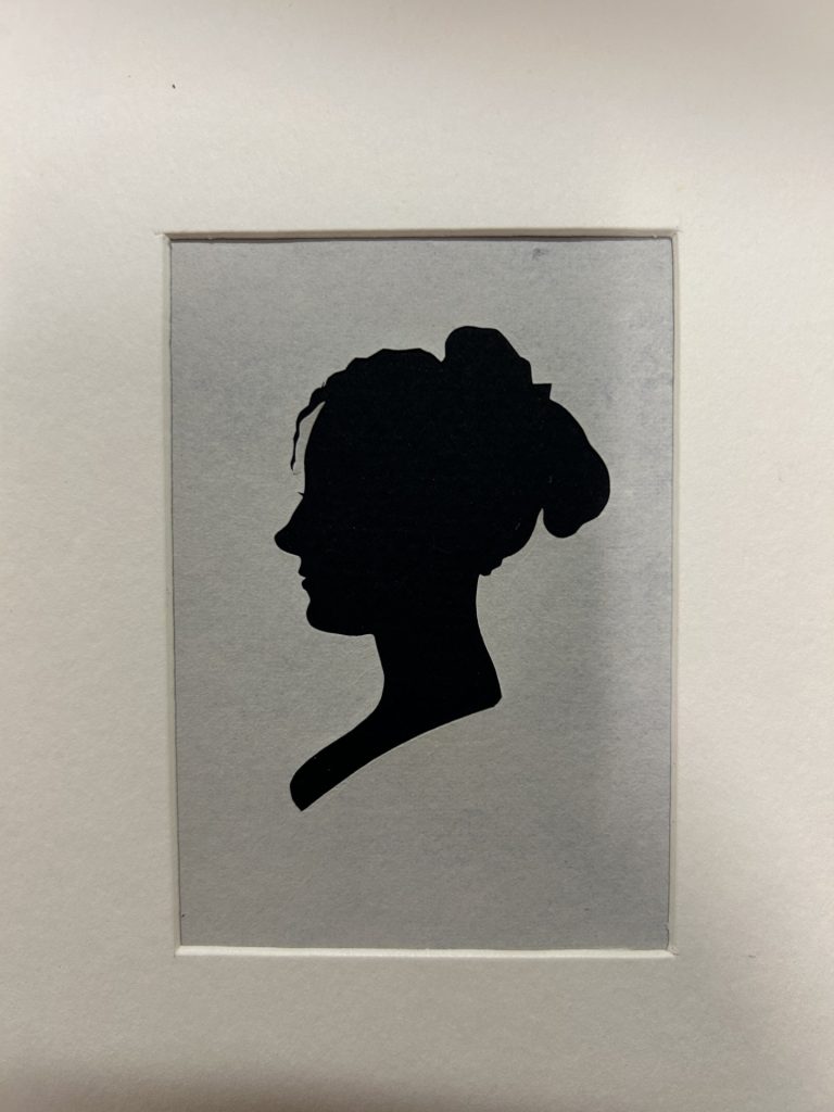
Susanna Boylston Adams (1796–1884) was the eldest daughter of Charles and Sarah Smith Adams (Sarah Smith Adams was the sister of William Stephens Smith, who married Charles’ sister Nabby!) Susanna and her younger sister, Abigail Louisa Smith Adams, spent much of their youth with grandparents John and Abigail after their father’s death in 1800.
Silhouette of Susanna Boylston Adams, by Boston artist Henry Williams
In 1817, Susanna married Lt. Charles Thomas Clark, who died two years later. She remarried in 1833 to William R. H. Treadway, who died in 1836. The Adams family provided her with financial support until her death. The first letter to Susanna in our collection is an 1808 letter from her grandmother, printed in volume 16, with most of her early correspondence falling into the timeline of volume 17. Her writings are even more frequent in the Adams Papers as she gets older.
Susanna was born during her grandfather’s presidency but grew up in the idyll of her grandparents’ farm in Quincy. Her social circle was filled with cousins (including Nabby’s daughter, Caroline Amelia Smith) as well as young women in the greater Quincy area, including Ann Hall, an orphan raised by the Adamses’ neighbors, and Ann Gerry, daughter of Elbridge and Ann Thompson Gerry. She also traveled locally, including to Newburyport to spend time with friends. In October 1810, Abigail wrote to her in Newburyport that this was the “first time you have gone so far from home without a guide.” She reminded Susanna about proper etiquette and social behavior.
Most of the extant correspondence is comprised of letters that Susanna received rather than those she wrote, but we are able to learn quite a bit about Susanna from her incoming mail and how often she addressed letters as her grandmother’s assistant. She had an especially close relationship with John Adams; Abigail noted he loved reading Susanna’s letters, hearing her sing and play guitar, and going on outings together, including a visit to the First Church of Weymouth.
For more on Susanna Boylston Adams, be sure to check out Adams Family Correspondence, volume 17, when it is published in 2027!
The Adams Papers editorial project at the Massachusetts Historical Society gratefully acknowledges the generous support of our sponsors. Major funding of the edition is currently provided by the National Endowment for the Humanities and the Packard Humanities Institute. Volume 16 and 17 of the Adams Family Correspondence also received support from the National Historical Publications and Records Commission.
By Michael A. Schoeppner, Andrew W. Mellon Short-Term Fellow, Associate Professor and Trustee Research Professor University of Maine-Farmington
Historians often go into the archives with specific questions in mind, and we can exhibit obscene levels of patience as we sift through materials in search of historical evidence to answer those questions. Many research trips yield more frustration than insight. But other times, not only do we find what we are looking for, we come across an item that speaks directly to us about our contemporary historical moment. I call this fortunate event an “archival surprise.”
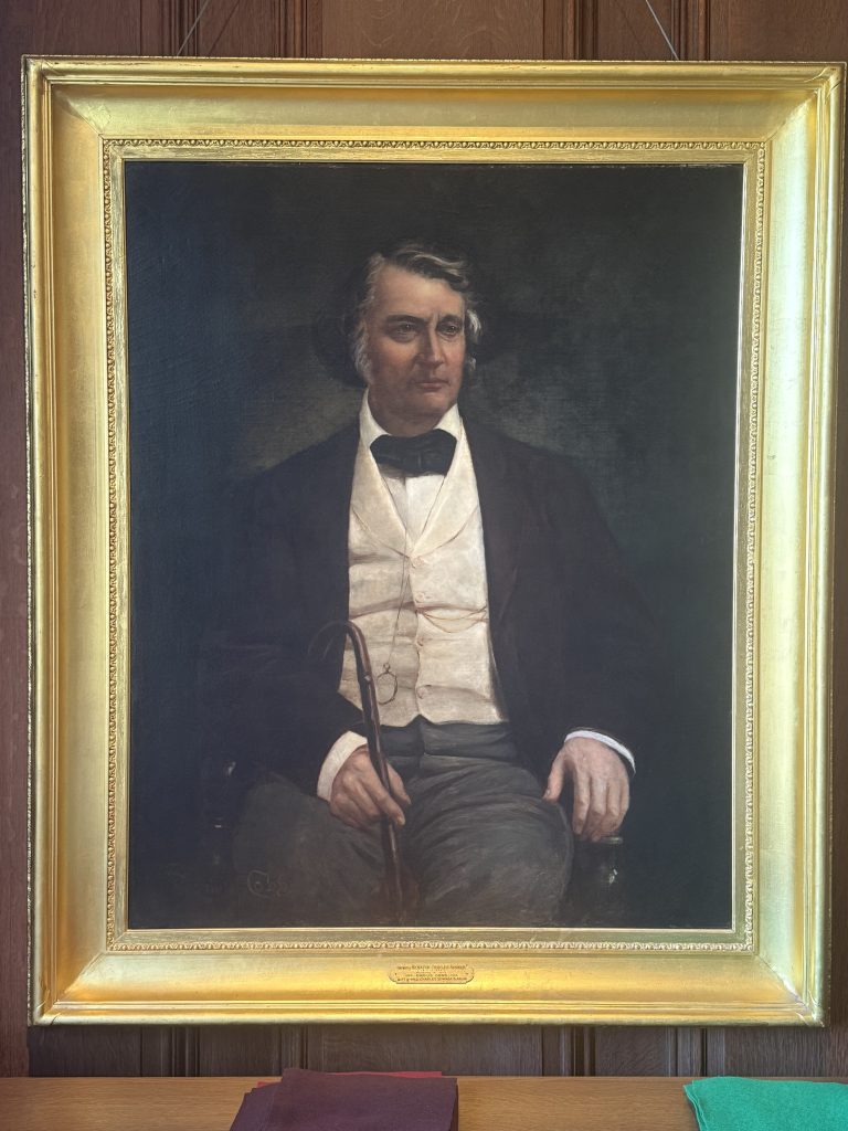
During my first week at the Massachusetts Historical Society, I was scrolling through the Winthrop Papers, a sprawling collection that contains multiple volumes from Robert C. Winthrop, former US Senator and US Speaker of the House. In 1843, Winthrop wrote a report about the imprisonment of Black people in Southern port cities. This report was central to my current research on the movement of free Black people before the Civil War and their ideas about citizenship. As I scrolled through Winthrop’s personal correspondence, I came across a letter from Charles Sumner, who was just cutting his teeth in public service when he wrote it. In the letter, he applauded Winthrop’s argument about Black people’s citizenship rights. I did not read the entire letter at first; I made an electronic copy to read later.
Two days afterwards, I was in the MHS reading room, exhausted from the previous evening’s doomscrolling over the recently argued birthright citizenship case currently before the Supreme Court. While I was waiting for a set of documents to be delivered, I read that letter from Charles Sumner. As I suspected, he held similar views as Winthrop regarding the citizenship rights that Black travelers ought to be entitled. But then, completely unsolicited, Charles Sumner wrote,
“The genius of our institutions invites immigration, but it does not say “come,” then add “but all who come must be of the purest white, and you cannot have offspring entitled to privileges + immunities of citizenship.” For whatever may be the conditions of the foreign immigrant under the Acts of Congress, I cannot doubt that his children, born in the United States, are citizens thereof.”
And just in case I was misreading Sumner’s rather deplorable handwriting, he reiterated in no uncertain terms,
“The accident of birth impresses upon the infant this indelible character. He becomes a citizen by birth within the jurisdiction of the Commonwealth, for then the C’wealth treats him as owing allegiance. He is one of her children. He is not a resident, but a citizen.”
I was shellshocked at how pertinent and precise Sumner’s position was. Given how essential he and other Radical Republicans were in the drafting and passage of the Reconstruction Amendments and the 1866 Civil Rights Act while Sumner was a US Senator, his views on immigrants’ birthright citizenship should be required reading for legal theorists. If anyone cared what the Radical Republicans meant when they proposed the 14th Amendment’s birthright citizenship clause, here was a powerful enunciation.
I swore Sumner was talking to me. Then I remembered the portrait hanging directly behind my table in the MHS reading room. I turned around, and Old Charles was there, sitting in his chair, staring down. His smug glare confirmed my suspicion. He wrote that letter to us as much as he wrote it to Winthrop. Here was an archival surprise, courtesy of Charles Sumner.
Portrait of Charles Sumner in the MHS reading room
Anyone who has spent considerable time in the archives has met with similar moments. Archival surprises are special rewards, a reminder that the past is not ever really past. It also confirms that public archives, such as the Massachusetts Historical Society, are invaluable cultural repositories.
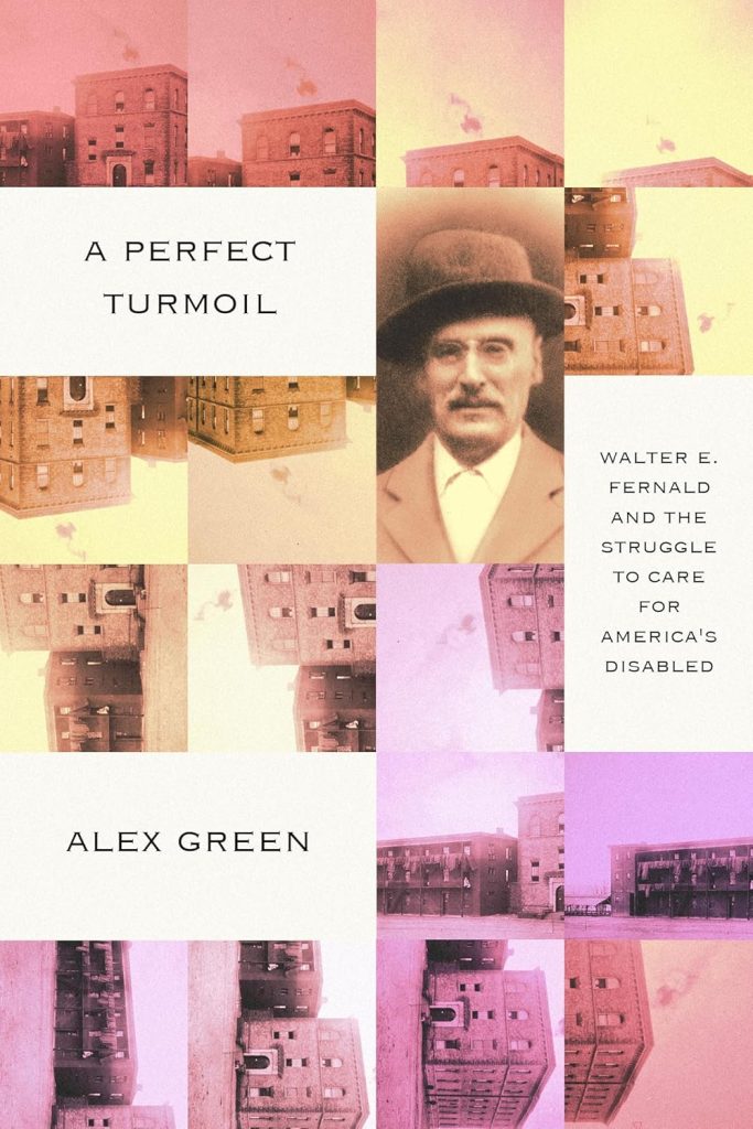
On February 12, 2026, the MHS welcomed Alex Green of the Harvard Kennedy School to give a talk on his book, A Perfect Turmoil: Walter E. Fernald School and the Struggle to Care for America’s Disabled. Green’s research has been ongoing, so he included information in his talk that he has uncovered since publication. It was a fascinating glimpse into a subject I have been researching in the MHS collection with my Disability in the Archive series, which you can check out in the further reading section. Green’s work looks at the ways disability was treated in Boston’s own backyard at the Walter E. Fernald State School in Waltham, Massachusetts.
Green’s book A Perfect Turmoil: Walter E. Fernald School and the Struggle to Care for America’s Disabled.
Green took us through the context around the creation of the Fernald School. He complicated the narrative of Walter Fernald, the man who founded the school, who was neither good nor evil. Through Green, the audience understood that Fernald was a man who was trying his best, even when his best failed people. Fernald was a eugenicist who eventually changed his opinion and fought against his prior beliefs. Green discussed the way the Fernald School was set up and the impact this particular school had on the education of disabled children in the United States, and later the world. Fernald believed that hard work and busyness could improve disabilities. Green pointed to the way the theories Fernald espoused are still present in special education practices around the United States today, and even presented his own rather radical idea that there should be no separation of disabled and abled children in schools.
However, Green did not shy away from the damage that Fernald’s theories created. He showed image after image of truly horrifying ways the students were treated, including being locked up, chained, and other brutalizations. Much of what he described was remarkably similar to the things I read in Dorothea Dix’s texts about the treatment of disabled people in jails and almshouses. The cruelty is still startling to me, no matter how many descriptions of it I read or images I see. And Green was clear about how cruel these things were. He was clear too about how that cruelty extended to the way the school handled the health and safety of these students. Those who died while attending the Fernald School, as well as the Metropolitan State Hospital, are buried in a cemetery on the grounds. I have been to the cemetery myself and the anonymity of the graves is as striking as Green said. It is not meant to be a place for loved ones to come and weep. And that is even more clear from Green’s explanation that sometimes families were never told what happened to their loved one who entered the school.
The research Green has done is not without controversy or challenges. Even accessing the records of the Fernald School at the Massachusetts State Archives was difficult, as a state law requires that an individual’s medical records remain private after their death, even to family members. He was able to get a court order to unseal them, but he noted his belief that these records should be accessible to survivors and family members without such extreme measures and described his frustration that only an Ivy League professor could access them. He also emphasized that much of the restricted material did not seem to be medical records at all, including drawings done by residents of the school and hospital. The issue of access to information is further complicated by the lack of centralization. As hospitals and schools closed, many of the records did not go to a single location or even an archive at all. In fact, many of these records have been sold on eBay and other similar sites in the ensuing years. It is a multi-pronged problem with no clear solution.
Green shared an important story. The brutality of what happened in these schools should not be forgotten or swept under the rug. The same ideas that formed the Fernald School are still present in American society today, as Green pointed out by linking the philosophy of Fernald to modern special education. Green demanded an unflinching look at the treatment of disabled people, one with compassion towards all but particularly towards the victims of an abusive system. It was a good reminder, and one we should take care to listen to.
Further Reading of the Disability in the Archive Series
Today I return to the diary of 13-year-old Henrietta Schroeder, part of the Stout family papers here at the MHS. Henrietta has made a big impression on me, with her unfiltered, exuberant, and irreverent writing style. She seems so relatable, so much like a teenager today. I hope you’ve been enjoying getting to know her, too.
We pick up our story on September 11, 1889. After spending the summer in the U.K., Henrietta and her family visited the continent, first France and then Switzerland. They landed at Dieppe, where Henrietta wrote in her diary (her “Cher Confidante”), “Now, surrounded by French people gabbling off French I really feel as though I were abroad.” She made herself right at home, polishing off three glasses of claret at one dinner.
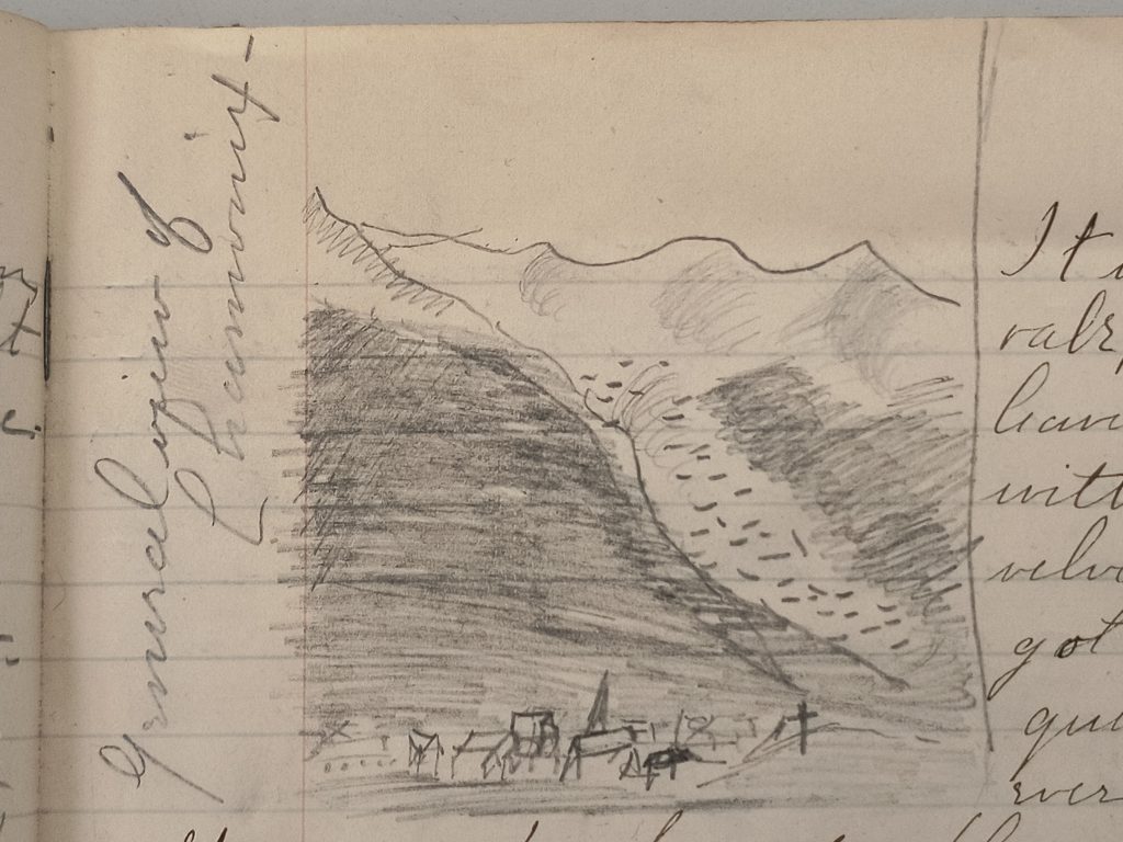
From Dieppe, the Schroeders went south to Rouen and Paris. They visited Rouen Cathedral, the burial place of Richard I’s “lion” heart and of “Henry the something of England,” as Henrietta put it. In Paris, they spent 5-6 days touring the famous Exposition Universelle, including the brand-new Eiffel Tower. Henrietta did ride the elevator to the top, but not until a few weeks later, so I’ll talk about that in a future post. She also saw Mont Blanc at Chamonix, France, which inspired her first original sketch in the diary.
“General view of Chamonix,” drawn by Henrietta Schroeder, September 29, 1889
But October 1889 was a relatively quiet month for the Schroeders, spent mostly at the Grand Hotel in Montreux, Switzerland. The hotel still exists today. It was there Henrietta spent her fourteenth birthday on October 9. Among her presents was a small ivory letter opener from her best friend Lina, which she cherished.
It was also on her birthday that the family toured Chillon Castle, where François Bonivard was imprisoned back in the sixteenth century. The castle seems to have genuinely spooked Henrietta. She wrote, “For the rest of the day I had the horrors. […] The Gallows were there, and a lot of other horrible things which I don’t want to write about.”
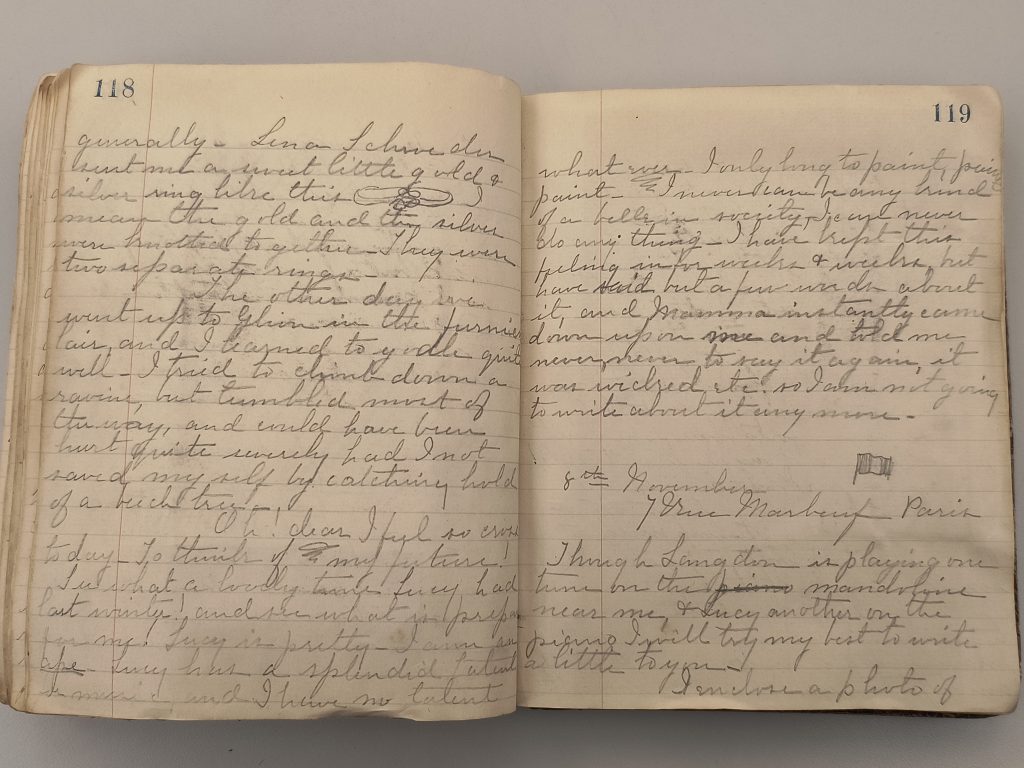
During this month-long pause at Montreux, Henrietta wrote in her diary a little more often and in a more introspective vein. Occasionally some of her fears and insecurities came through. While she was enjoying her European sojourn, she was also thinking about the future, which to her looked bleak.
Her older sister Lucy had “come out”—that is, debuted in society—the previous winter after her eighteenth birthday. Henrietta, five years younger, wondered what was in store for her. This passage made me want to give her a hug.
Oh! dear I feel so cross today – To think of my future! See what a lovely time Lucy had last winter! and see what is prepared for me! Lucy is pretty – I am an ape. Lucy has a splendid talent for music, and I have no talent what ever. I only long to paint, paint, paint – I never can be any kind of a belle in society – I can never do any thing – I have kept this feeling in for weeks & weeks, but have said but a few words about it, and Mamma instantly came down upon me and told me never, never to say it again, it was wicked etc. so I am not going to write about it any more.
Pages from Henrietta Schroeder’s diary, October 29 to November 8, 1889
I hope you’ll join me for my next post in this series here at the Beehive.
April 8, 2026, marks the 250th anniversary of the funeral of Dr. Joseph Warren, whose death at the Battle of Bunker Hill helped define the beginning of the American Revolution. After nine months in a shallow grave on the battleground on Breed’s Hill, his remains were recovered following the British evacuation of Boston and brought into the city for a ceremony that united Americans in renewed resolve.
Only thirty-four years old; a widower with four young children; newly engaged; admired for his intellect, courage, and striking presence; Warren was a leader of the colonists’ rebellion and embodied the promise of a rising nation. His death in battle quickly became a catalyst that spread revolutionary fervor throughout the colonies. Some historians have speculated that had he survived, Americans might today walk along “Warren Street” in every major city instead of “Washington Street.” News of his death raced through colonial newspapers, carrying shock and sorrow to communities that had never seen his face yet mourned him as one of their own.
Joseph Warren, by Edward Savage, after portrait by John Singleton Copley
By the time his remains returned to Boston for burial in April 1776, Warren had become the Revolution’s first great martyr—a figure whose courage at Bunker Hill and choice to fight beside ordinary militiamen rather than take command captured the spirit the colonies were beginning to claim as their own.
No contemporary voice captures the meaning of that day better than Abigail Adams. In a letter dated 7-11 April 1776 she wrote to her husband, John Adams:
“Yesterday the Remains of our Worthy General Warren were dug up upon Bunker Hill and carried into Town and on monday are to be interred with all the Honours of War.”
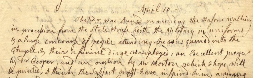
Three days later, she described the funeral itself:
“The Dr. was Buried on monday the Masons walking in procession from the State House, with the Military in uniforms and a large concourse of people attending… The amiable and heroic virtues of the deceased… the noble cause to which he fell a Martyr… must give weight and energy to whatever could be delivered upon the occasion.”
Excerpt of letter from Abigail Adams to John Adams, 7 – 11 April 1776
Her account evokes a city still bearing the scars of occupation, now gathered around Warren’s body “like that of Caesar’s before their Eyes” to confront the cost of liberty. The funeral procession made up of Masons in regalia, militia in uniform, and citizens in great number was one of the largest public gatherings Boston had seen since the outbreak of war.
Inside King’s Chapel, young attorney Perez Morton delivered an Eulogy that gave voice to the dead themselves. His most powerful passage urged the living to understand the depth of their betrayal and the justice of their cause:
“Ought we not to listen to the Voice of our slaughtered Brethren, who are now proclaiming aloud to their Country—
Go tell the King, and tell him from our Spirits,
That you and Britons can be Friends no more;
Tell him to you all Tyrants are the same:
Or if in Bonds, the never conquer’d Soul
Can feel a Pang, more keen than Slavery’s self,
‘Tis where the Chains that crush you into Dust,
Are forg’d by Hands, from which you hop’d for Freedom.”
Not merely a break with Britain, but the recognition that the oppression now suffered came from those once trusted to protect. For the mourners gathered around Warren’s coffin, this was not rhetoric, it was lived experience. For a city emerging from siege, the ceremony was both a memorial and a moment of political awakening.
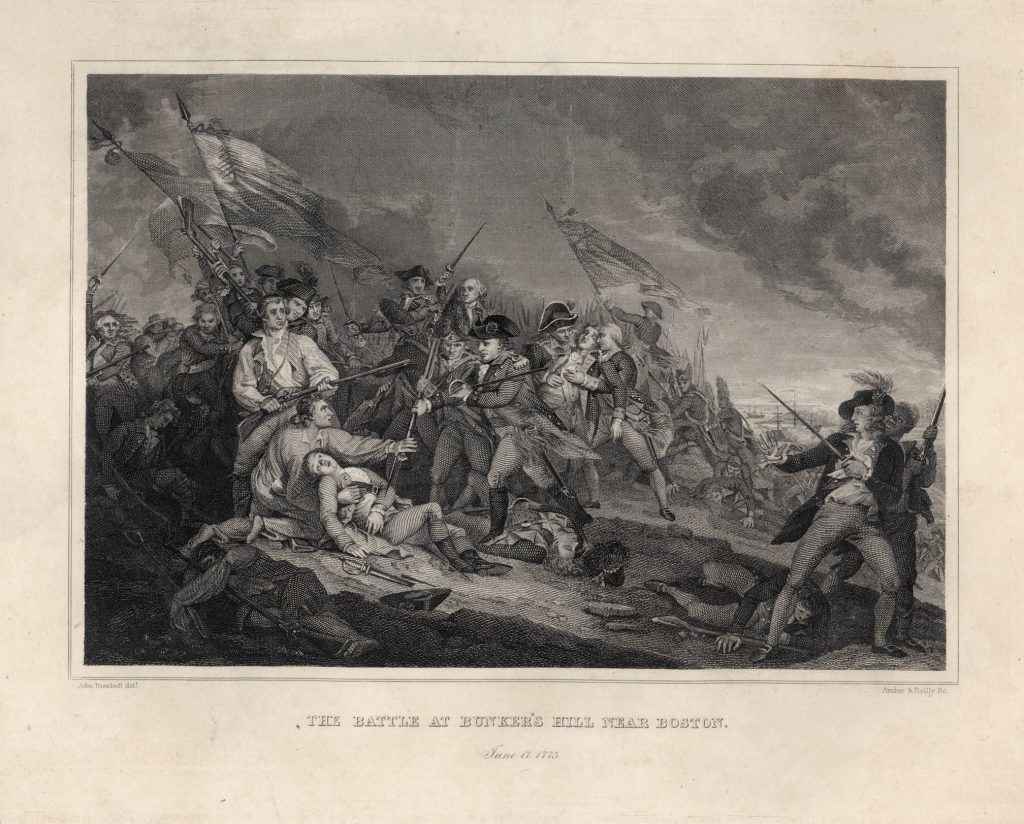
The Battle at Bunker’s Hill Near Boston. June 17, 1775, Engraving after painting by John Trumbull, 1786. John Trumbull’s paintings of The Death of General Warren at the Battle of Bunker’s Hill visually framed Warren as a martyr whose sacrifice sanctified the cause of Revolution.
On this 250th anniversary, we remember that Warren’s funeral was not merely an act of mourning. It was a public reckoning with sacrifice, betrayal, and the moral necessity of separation. In honoring Warren, the city made its own symbolic declaration of independence, months before Congress put the sentiment into words.
Visit the Massachusetts Historical Society for an in-person look at the documents that declared independence in the current exhibition 1776: Declaring Independence.
By Morgan S. Hardy, Mary B. Wright Environmental History Fellow (2025-2026)
It had been eleven years since loyalist Samuel Quincy left his hometown of Boston, Massachusetts. The Harvard-educated lawyer and friend of both John Adams and John Hancock fled Boston after the fighting at Lexington and Concord in 1775. Despite his self-exile, Samuel Quincy missed the comforts and staples of New England. In particular, he missed the taste of freshly salted Atlantic cod. In a letter dated March 4, 1786, Quincy wrote, “My Mouth has watered for their salt-Fish ever since your last letter.” Then, lamentingly, Quincy wrote, “I fear I never shall taste the Relish of the Quintal you say you bought for me.” Quincy never returned to Massachusetts after passing away in 1789.
Image of Cod fish From George Brown Goode, The Fisheries and Fishery Industry of the United States, (Washington, D.C.: Washington Government Printing Office, 1884), plate 58A. Drawing by H. L. Todd.
Salted Atlantic cod was New England’s most profitable export in the eighteenth century. This export was made possible through “curing,” a commercial process designed to prevent decay and turn perishable fish into durable products. However, only about two-fifths of the cured fish qualified as “merchantable” and were shipped to Spain, Portugal, and Italy for substantial profit. The remaining three-fifths were labeled as “refuse” fish. These badly cured, oversalted, or sunburned fish, among others, were sent to feed chattel slavery on Caribbean plantations. Fishers, shoremen, fishmongers, and parliamentary lobbyists all knew that nature influenced how well a fish cured.
Various weather conditions and fierce storms were among the notorious factors affecting the daily fishing life in New England. Fishers had to be hardy persons who were “oblig’d to life at the Mercy of the Winds, and [who] are often expos’d to Storms.” Good weather was always preferred for fishing, but it was never guaranteed. In September 1775, a giant storm struck the North American coast from Virginia to Newfoundland. A storm surge, over thirty feet high, wrecked the coast and caused chaos among the Newfoundland fishing fleet. It’s estimated that 4,000 people, mostly fishers, lost their lives. Storms and unpredictable weather emphasize the vulnerability of eighteenth-century fishing communities, making it tough to find, secure, and process salted Atlantic cod.
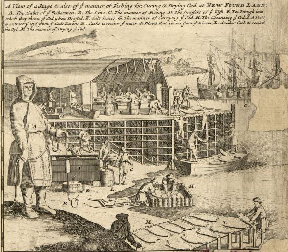
“A View of a Stage” depicting “the manner of Fishing for, Curing & Drying Cod.” This image is from a map by English cartographer Herman Moll published in 1718 based on a 1698 map by French cartographer Nicolas De Fer. Library of Congress, Geography and Map Division.
Being exposed to the “inclemencies of the severest weather [and] the dangers of the turbulent Atlantic” meant that New England fishers had to read the signs of the weather. This was helpful not only to avoid disasters while fishing but also for locating baitfish. New England fishers caught large amounts of baitfish, including herring, alewives, capelin, and squid, to catch other species such as the prized Atlantic cod and mackerel. John Knox, a Scottish philanthropist aiming to expand England’s fishing industry, reported in 1785 that “young herring always come in a body some time in June [but] their stay depends on the wind and weather.” Knox also noted that “herring shoals are subjected to the “tides, currents, and bays.” New England fishers relied on their understanding of weather patterns and the ocean’s depths to efficiently find, catch, and process the fish that supported their livelihoods. This knowledge was gained through extensive time at sea.
Samuel Quincy’s home of Boston was supported by fishers who understood that the environment posed a challenge to curing cod effectively. A fisher’s work, toil, and knowledge of the sea proved invaluable in making cod a profitable export and a local favorite. Salted cod’s unique, briny flavor was still prevalent to Samuel Quincy after almost a decade of fleeing Boston. Perhaps the next time you find yourself in Boston, try the salted cod—and remember that nature has been undermining human schemes for centuries.
Further Reading:
Letter from Samuel Quincy written from Tortola, March 4, 1786, Quincy Family Letters, Massachusetts Historical Society. Please note that a quintal was about 112 pounds of salted cod.
For how fishers were exposed to the elements, see “The Importance and Management of the British Fishery Consider’d,” (London, 1720), Folger Shakespeare Library, Washington, DC.
Chuck Lyons, “The Independence Hurricane: Chuck Lyons Examines the Events Around a Massive Storm That Brought Destruction to Newfoundland, and Likely Helped to Determine the Outcome of the American Revolution,” History Magazine 14.4 (Toronto: 2013): 24–26.
For inclemencies and herring, see John Knox, “A View of the British Empire: More Especially Scotland: with some Proposals for the Improvement of that Country, the Extension of its Fisheries, and the Relief of the People,” Volume 1 (London, 1785), Massachusetts Historical Society.
Recently I was reading a book by Tony Benn (1925-2014)—a British MP who, like Adams, was a politician for fifty years and kept a daily diary of how humdrum that seemingly glamorous life could really be. “Much of the casework,” he wrote, “fell into the same category as the palliative care offered by hospices. Support was needed whether or not you could actually solve the problem for a particular constituent. The people who wrote to me or queued up at my advice centers to tell me their problems wanted to be heard and wanted me to listen.”
I instantly thought of Adams.
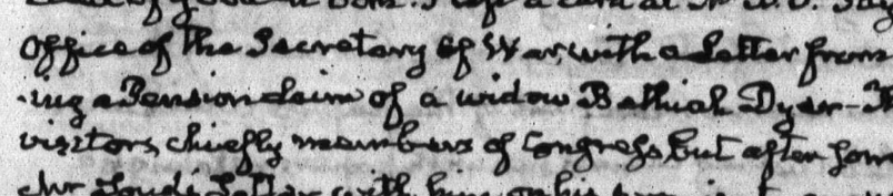
Adams’s diary is full of his constituents. He truly did view himself as their servant, advocate, and protector, as is clear from the time he dedicated to each one. On 17 December 1836, for instance, the 69-year-old congressional representative listened to the Collector of Customs at New York complain about merchants skirting consular fees. He tucked that away in his brain to bring up with the Committee of Manufactures the next week. Next, he heard out a disgraced English ophthalmologist who wanted to complain about his lot in life. (Again, palliative care.) Then, the elderly statesman walked through the rain to the Department of War to deliver a letter from a Plymouth widow seeking her husband’s pension. He carefully notes her name in his diary: Bethiah Dyer. He languished in the waiting room as the office was “beset with visitors,” then wouldn’t leave until he had the Secretary’s word that he would follow up with him.
A detail of Adams’s 17 Dec. 1836 diary entry mentioning Bethiah Dyer
This is one of about 17,000 days of JQA’s life that went that way. One of the most brilliant men of his age sitting in an unassuming room and just listening. Most people wanted something from him, but many came simply to gawp at him as a living curiosity. Anne Royall in her 1826 Sketches of History, Life, and Manners, in the United States wrote that JQA possessed “a calmness peculiar to him.” He was willing to sit silently and listen as long as you wanted to talk, giving you his undivided attention. “What most distinguishes his features, is his eye,” she wrote. “It is. . .one of such keenness that it pierces the beholder. He has the steadiest look I ever witnessed.”
The miracle of Adams’s devotion to his constituents is his further devotion to recording their dearest hopes and fears in his diary. Because of this, posterity has a window into the lives of thousands of ordinary Americans and their faith in the democratic process.
The Adams Papers editorial project at the Massachusetts Historical Society gratefully acknowledges the generous support of our sponsors. Major funding for the John Quincy Adams Digital Diary was provided by the Amelia Peabody Charitable Fund, with additional contributions by Harvard University Press and private donors. The Mellon Foundation in partnership with the National Historical Publications and Records Commission also supported the project through funding for the Society’s digital publishing collaborative, the Primary Source Cooperative.
This is the fourth part of a series. Read Part I, Part II, and Part III to catch up.
“Here I am in London, as big as life.”
These are the words 13-year-old Henrietta Schroeder wrote in her diary on August 15, 1889. She was on a European tour with her widowed mother and three siblings. The family had been traveling up and down the U.K. and would now spend three weeks in and around London before moving on to the continent.
Late Victorian London was a booming, bustling metropolis. The population of inner London alone was already over four million, quadruple what it had been at the start of the century. In 1889, it was the most populous city in the world, and Henrietta was very excited to be there.
As I’ve mentioned before, the Schroeders were indefatigable tourists, and in her diary Henrietta described the sights they saw and shared her unfiltered opinions. She thought Westminster Abbey was “lovely” and especially liked Poets’ Corner and the tomb of Queen Elizabeth. While there, unable to help herself, she had “leaned over, and touched the tomb of an old Saxon king, dated 616!!!” This was presumably King Saeberht of Essex.
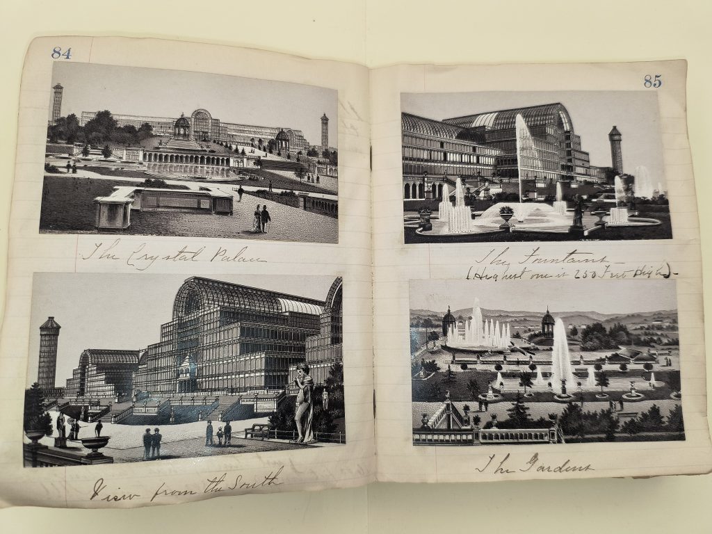
The family also visited the Victoria & Albert Museum in South Kensington, took a trip up and down the Thames to see the West and East India Docks, oohed and aahed over the Queen’s golden jubilee presents on display at Windsor Castle, and of course spent some time at the massive Crystal Palace. Henrietta pasted several prints of the building into her diary.
Prints of the Crystal Palace pasted into Henrietta Schroeder’s diary, 21 August 1889.
One attraction that didn’t overly impress Henrietta was Madame Tussaud’s Wax Museum, but that was probably because her mother didn’t allow her into the Chamber of Horrors. The Chamber of Horrors was home to what promotional material at the time called “the most extraordinary relic in the world,” the blade of a guillotine from the French Revolution.
Like many teenagers then and now (and a lot of adults, let’s be honest), Henrietta was fascinated by the more macabre parts of history. Her diary is full of references to historical figures who’d been imprisoned or stabbed or beheaded or tortured. She’d been delightfully spooked by the dungeons at Carlisle Castle. Now, after touring the Tower of London, she breathlessly recounted how she
“walked over the site of the scaffold where lady Jane Gray, Anne Boleyn and others were beheaded. And by the way, I saw the scaffold itself, STAINED WITH BLOOD!!”
Later she wrote about Canterbury Cathedral.
“You know that Thomas â Becket was murdered there? well, there is a little place marked where Tommie stood when he was murdered, and I stood on it too.”
In late August, the Schroeder family visited with some distant relatives in the wonderfully named village of Stoke Poges. Henrietta had mentioned the Gilliats before, but it wasn’t until this diary entry that I had enough information to identify them. The Schroeders were apparently guests at Duffield House, the home of Algernon Gilliat. He had three twenty-something sons, the youngest of whom later became both a footballer and an Anglican minister. If my research is correct, Algernon’s aunt married Henrietta’s uncle’s half-brother.
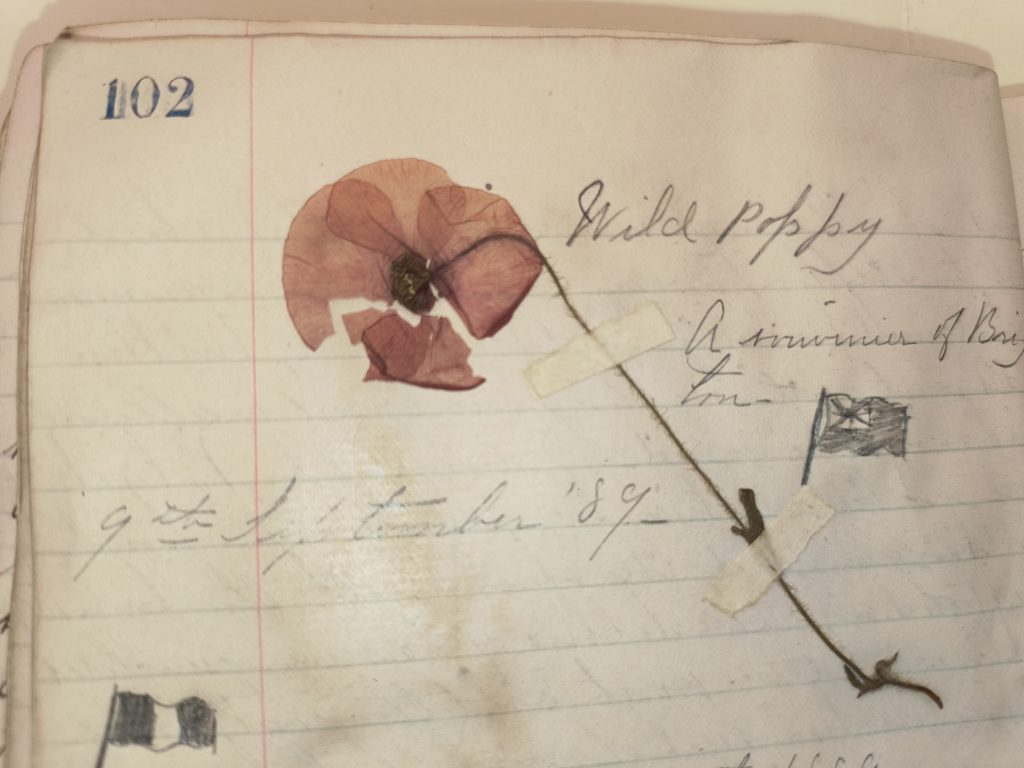
The U.K. portion of Henrietta’s diary ends, I think poignantly, with a single wild poppy she pressed into the volume on September 9, 1889. She explained, “When I pressed it, it turned purple, but it was scarlet once upon a time. The fields are red with them.”
Poppy pressed into Henrietta Schroeder’s diary, September 9, 1889
Stay tuned for more about Henrietta in my next post.